The world-famous Grand Canyon National Park was the last national park on this year’s 3,000-kilometer trip through Southern California and the Midwest of the USA. We drove into the Grand Canyon National Park from Antelope Canyon via the east entrance. That’s why we describe all the viewpoints on the South Rim from east to west in our travel report.

Table of contents
Interesting facts about the Grand Canyon National Park
The Grand Canyon National Park is located in the north of the US state of Arizona and covers an area of around 4,927 square kilometers. The heart of the park is the canyon, a gigantic gorge that has been carved into the rock layers of the Colorado Plateau by the Colorado River over millions of years. The gorge itself is around 446 kilometers long, up to 29 kilometers wide and reaches a depth of over 1,800 meters. The park borders the Kaibab National Forest to the north and the Navajo Reservation to the south, making it surrounded by an impressive natural and cultural environment.
The formation of the Grand Canyon began around 70 million years ago when tectonic forces uplifted the region and caused the Colorado River to carve into the rock. Over millions of years, the river cut deeper and deeper into the plateau, while erosion by wind and weather contributed to the formation of the striking cliffs and steep walls. The different layers of rock that are visible in the gorge today tell the story of around two billion years of the earth’s history and offer geologists and visitors alike fascinating insights into the earth’s past.
The most important sights in the Grand Canyon National Park include the South Rim and the North Rim, both of which offer spectacular viewpoints. The South Rim is accessible all year round and attracts the majority of visitors, while the North Rim is only open in the summer months due to its higher elevation. Popular attractions include the Bright Angel Trail, which leads down into the gorge, and the Desert View Watchtower, which offers breathtaking panoramic views. Visitors can also experience the Skywalk on the grounds of the Hualapai Reserve, a glass platform that juts out over the gorge and promises a thrill of a special kind.
The Grand Canyon – a UNESCO World Heritage Site
The Grand Canyon was declared a UNESCO World Heritage Site in 1979, underlining its global significance as one of the most impressive natural wonders on earth. The award recognizes not only the extraordinary beauty and geological significance of the Grand Canyon, but also its unique ecological diversity and cultural significance for indigenous peoples. With its designation as a UNESCO World Heritage Site, the Grand Canyon has been internationally recognized as a natural and cultural heritage site worthy of protection. The protected status has helped to protect the canyon from environmental threats such as mining and uncontrolled tourism.
Location, opening hours & admission
The Grand Canyon National Park is located in northern Arizona, around 100 kilometers north of Flagstaff and around 450 kilometers from Las Vegas. The park is divided into two main areas: the South Rim and the North Rim. The South Rim is the most visited part of the park and lies at an altitude of around 2,135 meters, while the North Rim is higher, at around 2,438 meters. Both areas offer breathtaking views of the gorge, but are separated from each other by the gorge itself and are around 350 kilometers apart by car.
The park’s opening hours vary depending on the season and location. The South Rim is open 24 hours a day all year round, which makes it particularly accessible. The North Rim, on the other hand, is only open from mid-May to mid-October due to its higher altitude and winter weather conditions.
There are several access roads to the Grand Canyon National Park. The most common route to the South Rim is via Arizona State Route 64, which branches off Interstate 40. State Route 67 is the main access road to the North Rim. As we had previously been to Monument Valley and Antelope Canyon, we came from the northeast via US Route 64, where the east entrance to Grand Canyon National Park, also known as the Desert View Entrance, is located.
Entry to the park costs USD 35 per vehicle and is valid for seven days. This pass provides access to both rims.
If – like us – you want to visit several national parks on your route through the USA, then we recommend the America the Beautiful Pass. This annual pass costs 80 USD and grants access to all national parks and other federally managed recreation areas in the United States for one year. You can easily buy the America the Beautiful Pass in almost every national park. Just ask at the ticket booth 🙂
You can find more information about the America the Beautiful Pass here.
Map of the Grand Canyon National Park
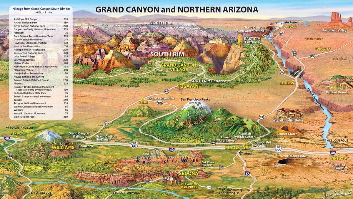
The following map clearly shows the Grand Canyon and the other sights in northern Arizona. The map can be downloaded here free of charge. Many other maps, e.g. of the South Rim or the North Rim, can be downloaded free of charge from the official website of the national park.

Grand Canyon and northern Arizona
Day trips to the Grand Canyon
If you are in Las Vegas, for example, and don’t have your own car or don’t want to drive the route yourself, you can book various tours to the Grand Canyon. Either by bus, plane or helicopter 🙂 At GetYoutGuide you will find a really large selection, depending on what you would like to experience.
Viewpoints at the South Rim of the Grand Canyon National Park
We drove into the Grand Canyon National Park from Antelope Canyon via the east entrance. That’s why we describe all the viewpoints on the South Rim from east to west here.
Navajo Point & Desert View
Our first stop was the large parking lot at Navajo Point near the east entrance to the national park.
Navajo Point is one of the most impressive viewpoints in the Grand Canyon National Park. It is located on the South Rim of the canyon and offers breathtaking panoramic views over the gorge. At an elevation of 7,461 feet (2,274 meters), Navajo Point is the highest viewpoint on the South Rim. From here you can see far-reaching parts of the canyon, including the Colorado River winding through the landscape below and the majestic desert landscape stretching to the horizon.
One notable feature that can be seen from Navajo Point is the Desert View Watchtower, a stone tower designed in the 1930s by architect Mary Colter. The tower is an iconic landmark designed to resemble an old pueblo tower and blend seamlessly into the natural surroundings.
Lipan Point
Our next stop was Lipan Point, another viewpoint in the Grand Canyon National Park. From Lipan Point you have a particularly good view of the deeply incised course of the river and the striking geological formations of the canyon. The view here is particularly fascinating, as you can clearly see the different layers of rock and their variety of colors.
Moran Point
Our next stop was at Moran Point. It was named after the famous American landscape painter Thomas Moran, whose paintings helped to publicize the beauty of the Grand Canyon and promote the creation of the national park.
Grandview Point & Horseshoe Mesa
About 10 kilometers from Moran Point is Grandview Point with more great views of the canyon and Horseshoe Mesa.
Horseshoe Mesa is a plateau that extends into the canyon like a horseshoe and was once the site of the Last Chance Mine Company, one of the most famous mining operations in the Grand Canyon. Copper was mined here in the 1890s, when the Grand Canyon was still largely undeveloped. Mining was dangerous and difficult, and the remote location made transporting the ore particularly challenging.
Duck on a Rock Viewpoint
The next viewpoint is the Duck on a Rock Viewpoint. It is named after a striking rock formation that looks like a duck sitting on a rock. The “duck” consists of a large rock that balances on a narrow ledge and is actually reminiscent of the shape of a duck. This natural sculpture is an example of the incredible forces of erosion that have shaped the Grand Canyon over millions of years.
Along the Desert View Drive we also saw deer and elk from time to time 🙂
Pipe Creek Vista
The next viewpoint on Desert View Drive is the Pipe Creek Vista. The special thing here is that you have a great view of the steep canyon rock face.
Visitor Center
The Grand Canyon Visitor Center on the South Rim of the Grand Canyon is a central point of contact for visitors who want to explore the national park. It is located near Mather Point, one of the most famous viewpoints with impressive panoramic views of the canyon. The center offers comprehensive information, including an information desk with rangers who answer questions and recommend hiking trails, as well as interactive exhibits on the geology and history of the Grand Canyon.
The Visitor Center is open all year round between 8 am and 3 pm, with varying opening hours depending on the season. We didn’t actually get to the visitor center until 4 pm, when it was unfortunately already closed. To be honest, we also think 3 p.m. is a very early time, especially with so many daily visitors. This was better organized in the other parks. In addition to the information on offer, the Visitor Center also has practical facilities such as a large souvenir store (open until 8 p.m.), a café and toilets. A free shuttle service provides convenient transportation to important viewpoints and hiking trails along the Rim. Short films highlighting the natural wonders, wildlife and cultural significance of the Grand Canyon are also shown regularly at the Visitor Center.
Mather Point
Mather Point is one of the most popular and easily accessible viewpoints on the South Rim of the Grand Canyon. It is located just a few minutes’ walk from the Visitor Center and offers one of the most spectacular panoramic views of the canyon. The point is named after Stephen Tyng Mather, the first director of the National Park Service, who played a central role in the promotion and protection of national parks in the USA.
From Mather Point, visitors have a breathtaking view of the deep gorges of the Grand Canyon and the Colorado River as it winds its way through the landscape.
Rim Trail
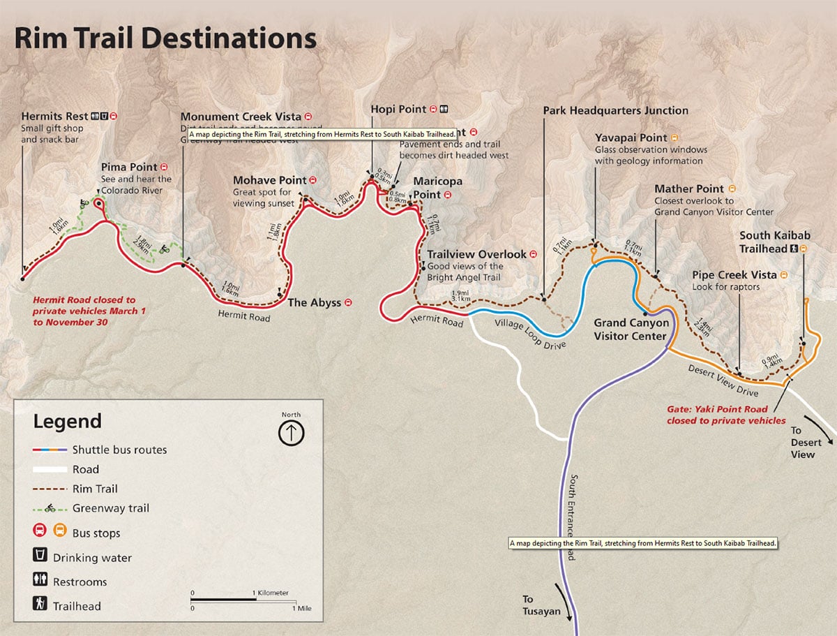
The Rim Trail at the Grand Canyon is a hiking trail that runs along the South Rim. It stretches about 21 kilometers (13 miles) from the South Kaibab Trailhead to Hermits Rest.
The Rim Trail is mostly flat, asphalted and has many sections that are accessible for wheelchairs and baby carriages. There are numerous viewpoints along the way, each offering a unique view of the mighty gorge and the rock formations below. Particularly noteworthy are Yavapai Point, known for its geology museum, and Maricopa Point, which offers a magnificent view of Bright Angel Canyon.
A map for the hike along the Rim Trail can be downloaded here free of charge as a .pdf version.
Is a visit to the Grand Canyon National Park worthwhile?
Definitely🙂 Seeing this unique natural wonder is something very special.
Our hotel at the Grand Canyon
There are several hotels and lodges within the national park, such as the El Tovar Hotel, the Bright Angel Lodge, the Maswik Lodge and the Kachina Lodge. However, we found the price incredibly high at 300 to 800 USD. There are also several RV campgrounds (Mather Campground, Trailer Village RV Park or Desert View Campground). However, you should book well in advance, as the campsites can get fully booked very quickly in the summer months.
You can stay overnight just outside the park in the small town of Tusayan, around 16 kilometers from the southern entrance to the national park. There are several hotels, restaurants, souvenir stores and tour operators, including helicopter flights.
Since we wanted to drive further west to Los Angeles along Route 66 after the Grand Canyon, we drove a little further in the late afternoon and looked for cheap accommodation in Williams, about 100 kilometers and 1 hour’s drive from the south entrance to the national park (location in Google Maps). Here we chose the Motel 6 for EUR 88 a night, but there are many other hotels in Williams.
Junior Ranger program for children
Desert landscapes, canyons, rocks and natural stone arches may not necessarily be the highlight for small children. However, to make exploring national parks a little more exciting for kids, there is a so-called Junior Ranger program in almost every large national park.The program is an exciting and educational way for children and young people to discover the nature and history of the national parks. A Junior Ranger booklet is available at the Visitor Center, which contains a series of tasks and activities specifically designed to promote an understanding of the nature, geology and culture of the park. These tasks range from puzzles and observations to small research assignments and art projects. The young explorers learn a lot about the animal and plant world, the history of the indigenous people, the special features of the rock formations and the protection of natural resources. Once they have completed the booklet, they can hand it in to a ranger at the visitor center. After a short “ranger ceremony”, the children then receive an official Junior Ranger badge, which then distinguishes them as ambassadors of the park.
At 3.5 years old, our daughter was still a bit too small for the tasks. But of course we got the Junior Ranger booklet anyway and if you ask nicely, you can of course also get the Junior Ranger badge. She was always very proud of it. And if you do this in several national parks, you end up with a nice collection 🙂


