A particular highlight of our trip through the US Midwest was a visit to the Bentonite Hills, a landscape reminiscent of Mars. We also discovered it by chance while looking for activities in Capitol Reef National Park. After seeing more and more fascinating pictures and drone videos of these colorful hilly landscapes on Instagram and YouTube, it quickly became clear to us – we want to see that too 🙂

Table of contents
The Bentonite Hills
What are the Bentonite Hills?
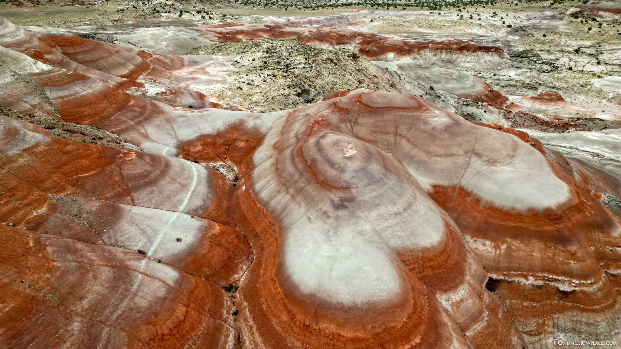
The Bentonite Hills are fascinating geological rock formations located near Capitol Reef National Park in the state of Utah. They consist of colorful clay and shale deposits that were formed millions of years ago by volcanic activity. The hills are characterized by their intense colors, which range from red and orange tones to shades of blue and purple. This variety of colors is created by different minerals that are present in the layers of the claystone.
The term “bentonite” refers to a type of clay that consists of weathered volcanic ash layers and has a high water absorption capacity. This characteristic causes the surface of the hills to turn into a slippery, almost clay-like substance in rainy weather, making the area difficult to access, especially in wet conditions.
The Bentonite Hills are known not only for their stunning colors, but also for their unusual textures and landforms. It’s like being on the surface of Mars or the moon. And indeed, the landscape here is said to be the most similar to Mars, which is why the government has set up the Mars Desert Research Station, a research center that simulates what life on Mars might look like.
Where are the Bentonite Hills located?
There is no “one place” for the Bentonite Hills, but several places where you can see the geological formations.
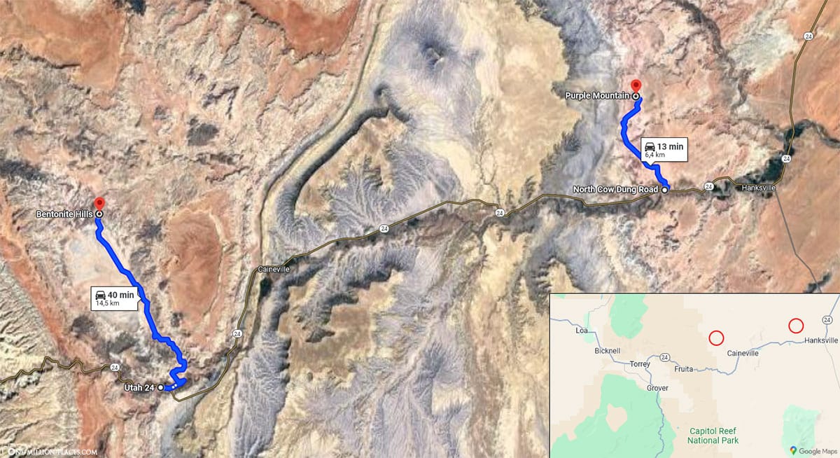
Two of the best-known places to admire the Bentonite Hills are north of Utah State Route 24, outside Capitol Reef National Park and completely off the beaten track. There are no buses, no houses, no toilets, no crowds… if only because the access roads can/should only be driven on with a four-wheel drive vehicle. Either way, you first have to drive part of Utah State Route 24, which in itself is embedded in a fascinating landscape 🙂
A map of the Bentonite Hills
The following map shows the location of the most famous spots in the Bentonite Hills in Utah.
Do the Bentonite Hills cost admission?
No, the visit is completely free 🙂
Guided tours
We rented a van for our round trip in the USA so that we had enough space for the children and our luggage. The van was also great, but without a four-wheel drive vehicle it quickly became clear to us that we wanted to book a guided tour to the Bentonite Hills. During our research, we had read in all the reports that it is not advisable to drive off-road in a normal rental car, especially if it has rained beforehand. There are potholes, washed-out depressions, stones and lots of sand everywhere, so you can quickly get stuck in a normal car. We didn’t want to risk that after all 😉
GetYourGuide has several providers and tours to choose from. We opted for the“Bentonite Hills 3-Hour Off-Road Tour” with the provider Meridian. As we were unsure whether this tour was suitable for small children and we didn’t want to convert the child seats, Michael did this tour on his own as a “Private Guided Tour”.
Our tour to the Bentonite Hills
The tour started at 6.30 pm and pick-up at the hotel was even included. We headed east along Utah State Route 24 and at Mile Marker 91 we turned left onto E 625 S (location in Google Maps). After about 500 meters you have to cross the Freemont River by car. There is no bridge or anything similar here, so you have to drive right across the river. It can have low water, but it can certainly be deep after rainfall. We certainly wouldn’t have dared to do it without a guide and 4×4 SUV 😉
We then continued on Hartnet Cathedral Road for about 14 kilometers on a bumpy gravel road with ditches and holes. We wouldn’t have made this road with our rental car. And then you are suddenly in an area with a large cluster of Bentonite Hills (location in Google Maps).
If you would like to take a look at the route to the Bentonite Hills, we have found a very detailed video on YouTube showing the entire route. So you get a great impression!
Our pictures of the Bentonite Hills
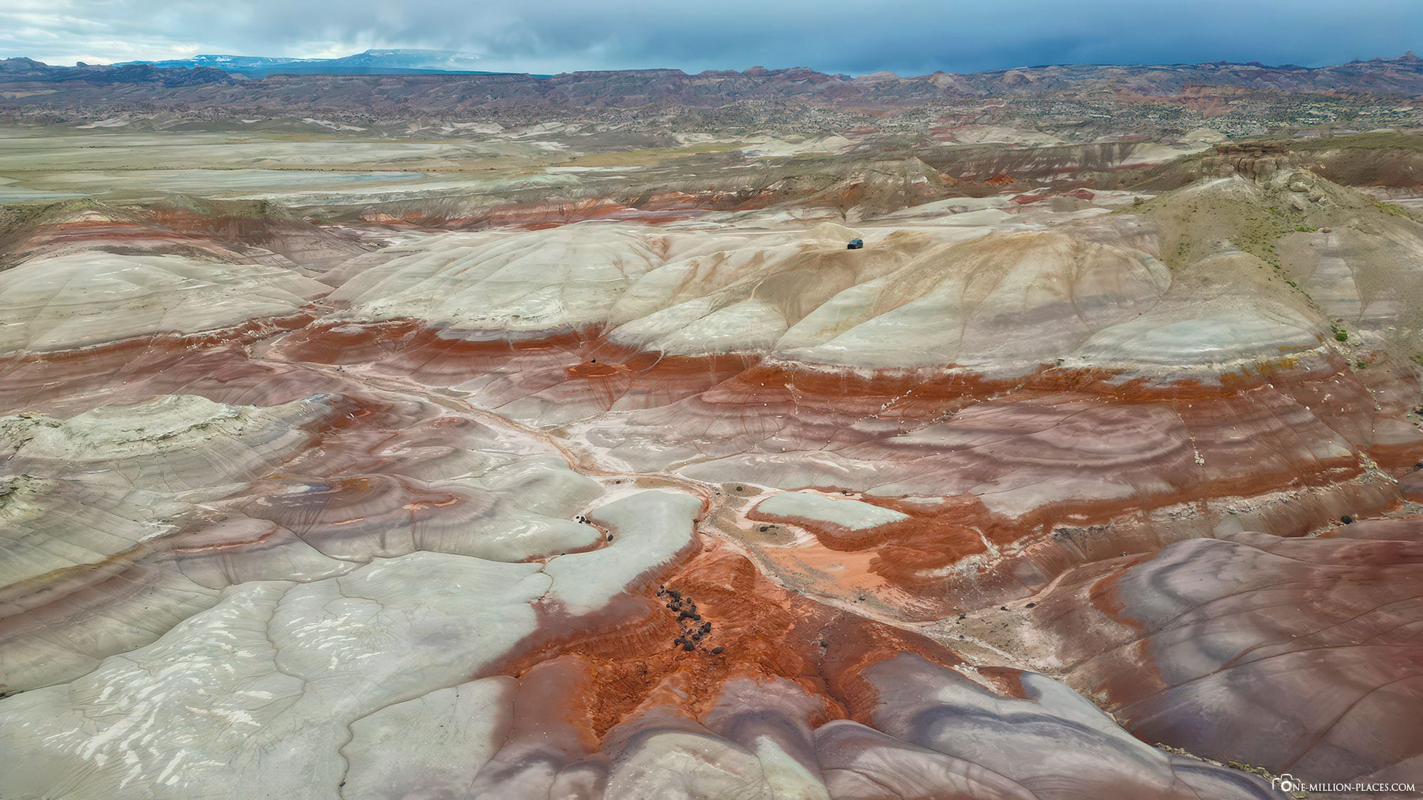
Our guide parked the car and then I had a good hour to photograph the landscape. I then walked up one of the hills a little further away and unpacked my drone. It was really windy that day, so our little DJI Mini had to fight to stay still in the air! Due to the many clouds, there was unfortunately no sun, so that the colorfulness was not quite as strong.
Nevertheless, we were able to get some great shots of this impressive landscape!
Are drones allowed in the Bentonite Hills?
If you want to capture the beauty of the Bentonite Hills, the best way is from the air. But are drones allowed here? Actually, yes🙂 The Bentonite Hills are federal land and lie outside Capitol Reef National Park. The use of drones is currently permitted in the area administered by the BLM (Bureau of Land Management).
What is the best time to visit the Bentonite Hills?
If you look at the many beautiful pictures of the Bentonite Hills, many of them are of course blatantly post-processed. And yet many say that the hills glow extremely brightly in a wide variety of colors, especially at the blue hour. The blue hour refers to the time of twilight, in the morning or evening, when the sun is just below the horizon and bathes the landscape in a soft, cool blue light.
What you should definitely avoid is a visit in the full midday sun. Then the hills should really be rather pale in color.
Our tour didn’t start until 6.30 pm, so we were there at 7.30 pm. So actually perfect for the blue hour. But on this day the weather was rather modest, very windy and extremely cloudy, so unfortunately no rays of sunshine could illuminate the hills. That was a bit of a shame, of course, but even so the view was fantastic.
Purple Mountains
Another famous location for the Bentonite Hills is a formation called the Purple Mountains on Google Maps. Unfortunately, we didn’t make it here due to time constraints. But we still want to write something about it in case you have the opportunity to visit it.
To get to the Purple Mountains, you have to turn onto Cow Dung Road on Utah State Route 24 at about mile marker 113. You then have to drive this unpaved off-road road for about 5.5 kilometers to the Mars Desert Research Station. The Mars Desert Research Station was built in the early 2000s and serves as a research center that simulates the conditions on Mars. Unfortunately, you are not allowed to enter the facility.
The Purple Mountains (location in Google Maps) are about another kilometer further on to the left.
Can we recommend a tour to the Bentonite Hills?
Yes, definitely! You don’t often see such a beautiful natural feature in the world and due to its remote location, not many people get to see it live.
Our tip: We found another spot on YouTube for beautiful photos and drone footage, this time south of Utah State Route 24 (location in Google Maps). You can find the video with the exact directions here.
Moonscape Overlook & Factory Butte
Just outside Capitol Reef National Park, there are two more sights that we would like to mention: the Moonscape Overlook and Factory Butte.
Factory Butte is a striking table mountain near the small town of Hanksville. It is known for its steeply sloping, almost vertical walls and its flat top, which gives it the appearance of a giant monolith or factory, hence the name. The shape is reminiscent of a gigantic, free-standing structure in an otherwise vast, open landscape.
We got to the Factory Butte with our van without any problems. From Utah State Route 24, take North Factory Butte Road (location in Google Maps). After about 9 kilometers you will see the huge Table Mountain on your left. The road up to here is really easy to drive on, we even saw a motorhome on the way 😉
At Factory Butte, we wanted to turn right onto Coal Mine Road, which leads to Moonscape Overlook. But from here the path becomes really uncomfortable with lots of potholes. A 4×4 all-wheel drive is not even necessary here, but you simply need a certain ground clearance, which our van did not provide. We touched down several times and then decided not to continue and to turn back.
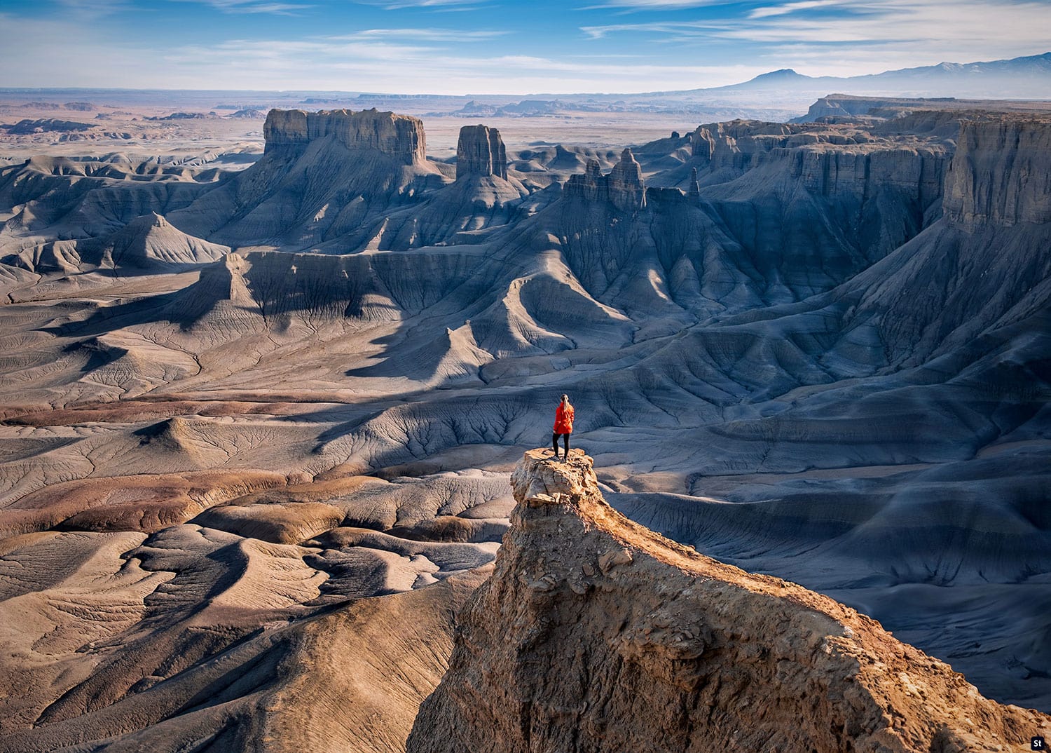
That was really annoying, because the viewpoint of the moonscape was perhaps only 1 mile away. But with 2 small children, we didn’t want to take this route on foot in the midday heat. So we only had the option of letting the drone take off to capture a few images of this surreal landscape.
And that would have been the view from the Moonscape Overlook that we were so looking forward to. But well, next time we’ll know better and just rent a big SUV or take a guided tour there 🙂
Our Hotel Capitol Reef Resort
Our hotel for the visit to the Bentonite Hills was the Capitol Reef Resort. This is only about 1.5 miles from the park entrance to Capitol Reef National Park and is a good starting point for exploring the Bentonite Hills. The hotel is a charming accommodation that offers a breathtaking view of the surrounding red rocks and the vast desert landscape. The resort offers a variety of accommodation options, ranging from classic hotel rooms and rustic wooden cabins to luxurious glamping tents and traditional tipis. Particularly noteworthy are the authentic western wagons, which are designed in the style of the pioneers and offer unique overnight accommodation.
We had a “Traditional 2 Queens” room and paid 336 EUR for 2 nights. Certainly not cheap accommodation, but the location is really perfect for exploring Capitol Reef National Park. The nearest small town, Torrey, is also only about 5 minutes away by car.
If you want to stay even closer to the Bentonite Hills, you should take a look at the small Cathedral Valley Inn hotel. It is perfectly located on Utah State Route 24, not far from the two turnoffs to the Hills.


