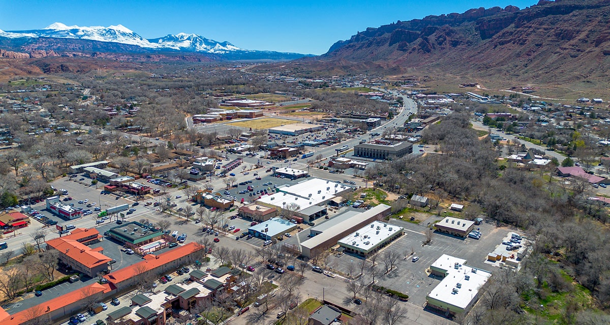
After our visit to Capitol Reef National Park and the Bentonite Hills, our journey through the Midwest of the USA continued north-east to the small town of Moab. This is the location of Arches National Park, which impressed us with its pictures when we were researching our trip. We were therefore very excited about our visit to the national park.
Table of contents
Things to know about the city of Moab in Utah
Moab is a small town in the south-east of the US state of Utah, located on the banks of the Colorado River. It is located near the eastern edge of the Colorado Plateau and is surrounded by impressive desert landscapes and red rock formations. The town is just a few kilometers from Arches National Park, known for its spectacular natural sandstone arches, and close to Canyonlands National Park, with its deep canyons and expansive views.
The history of Moab goes back a long way, with the first human settlements dating back to prehistoric Indian tribes. In the The area was explored by European settlers in the 19th century and settled by Mormon missionaries in 1855. In the middle of the In the 20th century, the town experienced an economic boom due to uranium mining, which led to rapid population growth. After the end of the uranium boom, the focus shifted to tourism, which is still the town’s most important source of economic income today.
Moab has a population of around 5,300 (as of 2020). Despite its small size, the city is a lively hub for tourists from all over the world. In addition to the national parks, the Moab Rim Jeep Trail and the Slickrock Bike Trail are very popular with off-road riders and mountain bikers. Other attractions include Dead Horse Point State Park, which is known for its spectacular sunsets. Moab also has a lot to offer culturally, with museums and galleries dedicated to local history and art.
Our tip: We really liked the Moab Food Truck Park. Here you will find many different food trucks, a large seating area and a great atmosphere!
In Moab we rented the vacation home Sunset View via Booking.com, which is located 5 minutes outside the city center. The vacation home was equipped with a living room, three bedrooms, a super equipped kitchen, two bathrooms and a washing machine and we really liked it.
The Arches National Park
Things to know about Arches National Park
Arches National Park is located in the east of Utah, near the town of Moab. It is home to the world’s largest concentration of natural sandstone arches – over 2,000 of these fascinating formations have been counted in the park to date. These arches are formed by the effects of wind, water and erosion on the soft sandstone rocks. The Delicate Arch, the park’s landmark and a symbol of the state of Utah, is one of the most famous and most frequently photographed arches.
The park covers an area of around 310 square kilometers and offers an impressive landscape of red rocks, deep canyons and unique rock formations. In addition to the famous arches, there are other geological features such as the Balancing Rocks, which look like huge boulders balancing on thin pedestals. The landscape of Arches National Park is also rich in desert plants and animals, including desert lizards, rattlesnakes and desert burrowing owls.
Arches National Park is open to visitors all year round, although the best time to visit is in spring and fall when the temperatures are more pleasant. Hiking is one of the most popular activities in the park, with the Devils Garden Trail and the Park Avenue Trail being particularly recommended. The park also offers excellent opportunities for photography, stargazing and exploring the desert landscape. Sunrise and sunset offer spectacular light conditions that bathe the red rocks in a warm glow and envelop the park in a magical atmosphere.
Opening hours, admission & reservation
Arches National Park is usually open around the clock all year round. The entrance fee is 30 USD per vehicle.
PLEASE NOTE: For the Arches Nation Park you have to reserve fixed times for your visit in advance!
The Timed Entry Reservation System in Arches National Park was introduced in 2023 to better manage visitor flows and protect the environment. This system requires visitors to reserve a time slot for arrival in advance. The background to this measure is the increasing number of visitors, which can lead to overcrowding and the associated negative impact on nature and the visitor experience, especially during the high season. For comparison: in 1980, just 290,000 visitors came to the park, in 2010 it was already over 1 million and in 2021 already 1.8 million visitors.
If you want to visit Arches National Park from April to October between 7 a.m. and 4 p.m., you must book a reservation in advance for USD 2 on the website www.recreation.gov.
GOOD TO KNOW: If you don’t have a reservation, you can still visit Arches National Park. Without a reservation, you simply have to get up early and enter the park before 7 am and/or after 4 pm.
We had only seen the information about the reservation by chance about 4 weeks before our visit and were just able to buy the last available tickets for our day. This requires some planning, as the system works in such a way that visitors have to select a specific time at which they want to enter the park. And the timeslot is always only 1 hour. So you have to know relatively precisely when you will be at the park entrance. And the queue at the entrance can be very long! We saw a sign there – similar to an amusement park – with “Waiting time from here 45 minutes”. You should also bear this in mind when planning your time. We had reserved an entry slot for Arches National Park between 9 and 10 am and were at the park entrance on time at 9 am 🙂
It is also important to know that this reservation does not replace the entrance fee to the park. Visitors must still pay the regular entrance fee of 30 USD per vehicle or, like us, have an America the Beautiful Pass.
If – like us – you want to visit several national parks on your route through the USA, then we recommend the America the Beautiful Pass. This annual pass costs 80 USD and grants access to all national parks and other federally managed recreation areas in the United States for one year. You can easily buy the America the Beautiful Pass in almost every national park. Just ask at the ticket booth 🙂
You can find more information about the America the Beautiful Pass here.
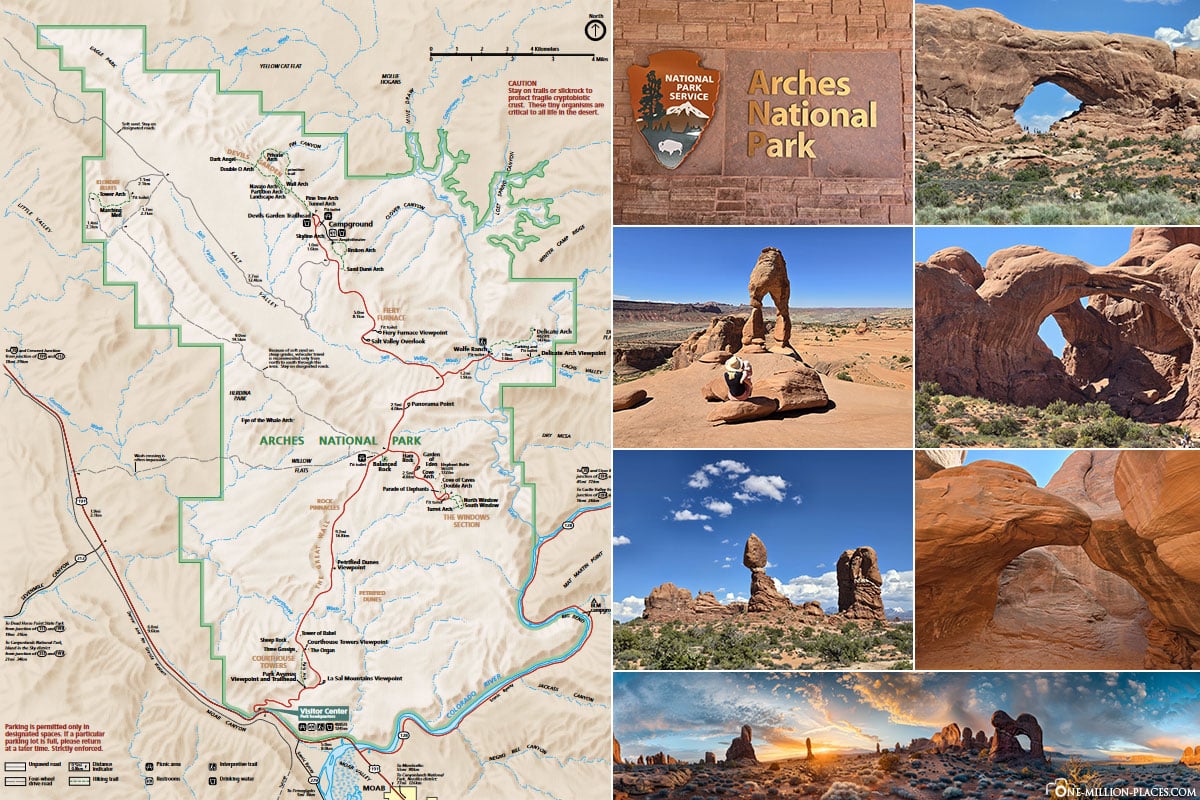
Map of Arches National Park
On the following map you can see the size of the national park and the most important sights. This map can be downloaded here free of charge as a .pdf version.
Visitor Center
The Visitor Center is located directly at the entrance to the park. The modern building is designed to blend harmoniously into the surrounding desert landscape and at the same time offers a great view of the red rock formations. In the Visitor Center, visitors will find informative exhibitions that provide an overview of the geology, history and ecology of the park. Here you can learn how the iconic sandstone arches and rock formations were created by erosion over millions of years. There is also information about the flora and fauna of the park and the cultural significance of the area for the indigenous peoples.
The visitor center also has restrooms, drinking water dispensers, a gift store and an information station where park rangers are available to answer questions. These rangers also offer guided tours and programs that provide insights into the special features of the park. Timed Entry Reservations can also be confirmed or changed here if necessary.
The Visitor Center is open daily from 7.30 am to 6 pm.
Delicate Arch
Our first stop in Arches National Park was the parking lot at Wolfe Ranch for the hike to Delicate Arch. We were here at around 9.30 am. The parking lot was still quite empty – but we have read that the parking lot can fill up very quickly, especially during peak season. As the hike to Delicate Arch is around 4.8 kilometers long (there and back) and involves a height difference of 146 meters, we wanted to do it as early as possible to escape the heat of the midday sun.
We took both of our kids in a stretcher. Our three-year-old daughter also walked by herself from time to time. The Delicate Arch Trail also starts off fairly easy and level, but then climbs steeply relatively quickly. It’s also worth looking to the left and right of the path – we spotted a snake under a stone, for example 🙂
The steep part of the trail begins at about the halfway point. Here you hike on a huge rock slab and the path continues upwards. With the extra weight of two children in the stretcher, it’s exhausting and many hikers looked at us with admiration 😉
It took us exactly 45 minutes to climb up and then it was finally done… The Delicate Arch lay before us. Mega!
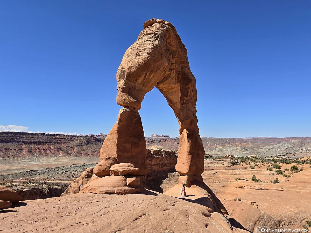
The Delicate Arch is probably the best-known natural wonder in Arches National Park and one of the most famous landmarks in the US state of Utah. This freestanding sandstone arch rises to a height of around 20 meters and has a span of around 10 meters. Its elegant and fragile appearance gives it its name and makes it one of the most photographed and visited places in the region. The Delicate Arch is so iconic that it can even be found on the license plates of the state of Utah🙂
The arch was formed by natural erosion over millions of years, when wind, water and other natural elements slowly shaped the sandstone. The Delicate Arch stands alone on a rocky plateau and offers a breathtaking panoramic view of the surrounding landscape of the national park.
You have to queue up for a photo here, because of course everyone wants to stand under the rock arch. But that actually went quite quickly and so we were able to take several pictures.
We spent about 45 minutes up here, enjoyed the great view and also took a little snack break. Our tip: make sure you take plenty of water, something small to eat and lots of sunscreen. There is hardly any shade on the route and at Delicate Arch. It took us a good 40 minutes to get back.
In total, we spent a lot of money on the Delicate Arch Trail there and back incl. break and 2 children in the stretcher took a good 2.5 hours.
If you can’t make the hike to Delicate Arch but still want to see the stone arch, there are two viewpoints: Upper Delicate Arch Viewpoint and Lower Delicate Arch Viewpoint. These are located at the end of Delicate Arch Road. The Lower Viewpoint is located directly at the parking lot, the hike to the Upper Viewpoint is 0.8 kilometers there and back.
Skyline Arch Trail
Next, we made a short photo stop at the Skyline Arch Trail.
The Skyline Arch is a natural sandstone arch in the northern part of the park, near Devil’s Garden Campground. The arch gets its name from its positioning, which makes it stand out against the sky, giving it a particularly dramatic appearance. The Skyline Arch has a span of around 22 meters and a height of approximately 10 meters. What is remarkable about its history is that the arch grew considerably in size in 1940 when a large boulder suddenly broke out of the upper part of the arch. This incident almost doubled the size of the opening and made the Skyline Arch even more impressive.
The hiking trail to Skyline Arch is very short and easy: only about 0.6 kilometers there and back.
Devils Garden Trail
The Devils Garden Trail is one of the most famous and longest hiking trails in Arches National Park and offers an impressive variety of rock formations, including some of the most spectacular natural arches in the park. The trail stretches for around 12 kilometers (there and back) and leads hikers through a varied landscape of sandstone cliffs and rugged canyons. However, we only walked part of the trail.
The trail begins at the Devils Garden Trailhead, which is located at the end of the park’s main road. From here, the trail leads to several famous arches such as the Landscape Arch, Navajo Arch, Partition Arch and the Double O Arch. The trail also offers the opportunity to explore the more challenging Primitive Loop, which is less frequented. This part of the trail requires some climbing passages and is more suitable for experienced hikers.
Landscape Arch
The Landscape Arch is one of the most famous rock formations in Arches National Park. With a span of around 93 meters, it is the longest natural arch in North America and one of the longest in the world. The bow is remarkably thin and fragile, giving it an almost unreal appearance. It literally seems to float in the air. The arch is located along the Devils Garden Trail and can be reached after a relatively easy hike of around 2.9 kilometers (there and back) from the trailhead.
The Landscape Arch has undergone several significant changes in recent decades. In 1991, several large boulders fell from the thinnest part of the arch, further accentuating its already delicate appearance. Due to these events, the area under the arch was closed to visitors to ensure safety. However, you can still admire the Landscape Arch from a nearby viewpoint.
Pine Tree Arch & Tunnel Arch
From the Devils Garden Trail, a short diversion leads to the viewpoints for the Pine Tree Arch and the Tunnel Arch.
The Pine Tree Arch is at ground level and has a wide, almost symmetrical opening surrounded by sandy soil and desert vegetation. The name “Pine Tree Arch” comes from the juniper trees that grow near the arch and can be seen through the opening. The cool thing is that you can even walk through the large opening of the Pine Tree Arch.
The Tunnel Arch looks like a large tunnel that has been carved into the massive rock face by erosion. It consists of two large openings that are slightly offset next to each other.
Broken Arch & Sand Dune Arch
Our next stop was the trailhead to Broken Arch and Sand Dune Arch.
The Broken Arch is characterized above all by its unusual shape and location. Despite its name, the Broken Arch is not actually broken; rather, it has a clear crack in the middle of its arch, which has earned it this name.
The hike to Sand Dune Arch from the parking lot is about 1.6 kilometers (there and back). The path leads through narrow gorges and soft sand dunes. The Sand Dune Arch itself is particularly impressive because it is located in a gorge of red rocks, whose shape and structure provide a beautiful contrast to the fine, light-colored sand.
Fiery Furnace Viewpoint
A short turnoff from the Arches National Park Road is the Fiery Furnace Viewpoint.
The Fiery Furnace Viewpoint is a vantage point that offers a panoramic view of the unique rocky landscape of the Fiery Furnace. This area of the park is known for its complex geology, which is characterized by a labyrinth of narrow canyons, high sandstone walls and unusual rock formations. The name “Fiery Furnace” comes from the intense red and orange colors of the sandstone, which glow like flaming embers in the sunlight. Access to the Fiery Furnace itself usually requires a guided tour, as the area is complex and slightly confusing and orientation can be difficult without professional help.
Double Arch
As the name suggests, the Double Arch consists of two interconnected arches that rise up next to each other and are connected by a common base. The formation is located in the southern part of the park, near the parking lot and the trailhead for the North and South Window. The Double Arch is characterized by its massive and striking structure. The larger of the two arches has a span of around 32 meters, while the smaller one is around 21 meters wide.
The Windows Section
The Windows Section includes two main arch formations known as the North Window and South Window, as well as a smaller formation known as the Turret Arch. These arches are connected by a short and picturesque hike of around 2.4 kilometers (there and back).
Balanced Rock
Balanced Rock is certainly one of the most photographed rock formations in Arches National Park. The rock consists of a massive sandstone block balanced on a much narrower base, which gives it its striking appearance. The Balanced Rock is about 16 meters high and looks as if it is about to fall over, even though it has been in this position for millions of years 🙂
Good to know: In the winter of 1975, the “Chip-Off-the-Old-Block” collapsed, its little brother right next to Balanced Rock. You can also have a look at the Then & Now page of the National Park Service. It does a great job of showing how some of the rock formations in Arches National Park have changed over the decades.
Park Avenue
Park Avenue was our last stop in Arches National Park before we drove back towards the exit. Park Avenue offers a great view of the monumental sandstone formations, which are reminiscent of an urban skyline and give the route its name. The rocks rise up to the left and right like tall buildings along a road and with some of the rocks at the top you wonder how long they will last 🙂
More beautiful photo spots in Arches National Park
If you drive through the Arches National Park, you will find a new beautiful photo motif every few meters 🙂
Is a visit to Arches National Park worthwhile?
Definitely yes! Arches National Park is definitely one of the highlights of our round trip through the Midwest of the USA. We arrived at the park at around 9am and left at around 5.30pm. We were able to see an incredible amount and go on some beautiful hikes. To explore the entire park, however, you will certainly need 2-3 full days 🙂
We have transferred all the sights and photo spots from this article to an extra Google MyMyps map. This always helps us on site to get to the individual points quickly and not forget anything. If you are also mobile in the USA (we always get a USA SIM card with unlimited data in advance), then you can use this Google MyMaps map for Arches National Park.
Junior Ranger program for children
Desert landscapes, canyons, rocks and natural stone arches may not necessarily be the highlight for small children. However, to make exploring national parks a little more exciting for kids, there is a so-called Junior Ranger program in almost every large national park.The program is an exciting and educational way for children and young people to discover the nature and history of the national parks. A Junior Ranger booklet is available at the Visitor Center, which contains a series of tasks and activities specifically designed to promote an understanding of the nature, geology and culture of the park. These tasks range from puzzles and observations to small research assignments and art projects. The young explorers learn a lot about the animal and plant world, the history of the indigenous people, the special features of the rock formations and the protection of natural resources. Once they have completed the booklet, they can hand it in to a ranger at the visitor center. After a short “ranger ceremony”, the children then receive an official Junior Ranger badge, which then distinguishes them as ambassadors of the park.
At 3.5 years old, our daughter was still a bit too small for the tasks. But of course we got the Junior Ranger booklet anyway and if you ask nicely, you can of course also get the Junior Ranger badge. She was always very proud of it. And if you do this in several national parks, you end up with a nice collection 🙂
Colorado River & the colorful Potash Ponds
When we looked at the area around Moab on Google Maps, we immediately noticed the colorful potash ponds. That’s why we made another little trip here the next morning. The drive follows Utah State Route 279 along the Colorado River and offers great views of the river. At some point, the road becomes a gravel track and has more and more potholes. That was a bit too tricky for us with our rental car and we only got as far as just before the Potash Ponds.
But luckily we had our drone with us and were able to get some nice shots of the surroundings and the colorful ponds. These artificial evaporation ponds are part of the Potash Mine, which is located west of Moab along the Colorado River and is used to extract potassium carbonate (potash), which is mainly used in fertilizers.


